Accurate early warning of poor air quality is an essential component of responsible air quality management. Forecasting impacts from fast-acting events such as the recent California forest fires is top of mind – tens of millions of people were affected from exposure to dangerous levels of particulate matter and other fire-related pollutants.
In the case of the recent Camp Fire in Northern California, smoke travelled hundreds of kilometres from its source, affecting large populated areas of Sacramento and the San Francisco Bay area, closing schools, office buildings, supermarkets and facilities that we take for granted.
Smoke movement and community health protection
Smoke management is a critical aspect of wildland fuels reduction. Airborne smoke particles generated by burning biomass, especially particles smaller than 2.5 um in diameter (PM2.5), pose potential health, visibility, safety and nuisance problems.
Until recently, air quality managers made decisions based on the air quality index or ‘AQI’. Although very useful for calculating impacts, the AQI value is based on past data, not always useful when looking for immediate information during a critical event such as the wildfires in California.
Predicting smoke plumes that originate from forest fire events and impact on populated regions is complex. The advent of low-cost real-time sensor technology, use of algorithms including trajectory–based receptor modelling and other technological advancements such as NASA's near-real-time satellite data has opened a wealth of possibilities for improved air quality management and forecasting.
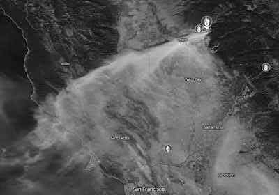
Shot taken from NASA's 'World View' of Northern California's Camp Fire air quality event on November 8, 2018.
Faster warnings of severe air quality events
At Envirosuite, we are working on approaches to improving air quality prediction for cities and regions, including neural networks and specialised atmospheric models, and looking at how new data sources such as NASA’s GOES 16 and 17 satellites can give communities better and faster warnings of poor air quality when integrated in a smart real-time system.
Our hope is that with better data management from local weather model outputs, emission source information and environmental monitoring data local regulators and city officials can get better insights into airshed management and protecting community health.
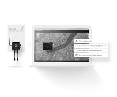
An example of Envirosuite's 'Forward Trajectory' modelling for potential air quality impact on a nearby community. This allows city officials and regulators to provide early warnings of air quality impact to communities.